
Thursday, 28 September 2017
RAILWAY BRIDGE - RAISED KERBS
Residents may have noticed officers from CE Highways carrying out an inspection of the railway bridge on London Road/Wilmslow Road earlier today. This is in preparation for raising of the kerbs and footpaths on the westerly side of the bridge and follows an assessment by Network Rail into the likelihood of a vehicle ending up on the railway line in the event of a collision. Unfortunately, it will be necessary for the bridge to be closed for a period of one week whilst the work is undertaken; however, the good news is that CE Highways intend to resurface Wilmslow Road at the same time. I will give a further update when I have more information regarding the timescale for the project.
Wednesday, 27 September 2017
CONGLETON ROAD - PEDESTRIAN REFUGE
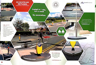
I am pleased to report that I am in discussion with CE Highways with a view to installing a central reservation on Congleton Road. The purpose would be to create a safer crossing point near Woodlands Court, as I have recently been contacted by elderly residents who have experienced difficulties in accessing the Bus Stop on the opposite side of the road. A central reservation would also act as a traffic calming measure, by narrowing the surface of the road at this location. Please let me know whether or not you agree that this would be a good idea. The scheme would be funded through residual Section 106 monies raised on the TESCO Express development on London Road.


JUNCTION PROTECTION - OAKHURST CHASE
I am pleased to report that the junction protection at Oakhurst Chase, announced recently via this blog, has now been completed. This scheme will be important in helping to improve visibility splays to Brook Lane, for residents and visitors to Oakhurst Chase. It will also help to facilitate access to and egress from Brookview Care Home by delivery vehicles. I would like to thank CE Highways for implementing this project so quickly, following my request earlier in the summer.


CEC TO LET LAND OFF WILMSLOW ROAD
I have been advised by CEC Assets Team that land to the west of Wilmslow Road (currently owned by the Council) is to be advertised "to let" for grazing purposes. I have quizzed CEC further to ascertain their intentions for the site and they have confirmed that this decision has been taken following the decision by Alderley Edge School for Girls not to proceed with their plans for the site. Lee Beckett (CEC Assets) confirmed to me that "to ensure the land is managed, maintained and that the Council receive a little income, then we are proposing to let the land on a temporary basis for grazing." The land in question lies opposite the Ryleys School Playing Field and is not the land in which David Wilson Homes have expressed an interest, which is in private ownership.


Monday, 25 September 2017
TRAFFIC SURVEY RESULTS
Earlier today I joined some of the Parish Councillors to collect traffic data at the junction of Ryleys Lane and Wilmslow Road. The purpose of the survey was to record how many vehicles were diverted through the village as a result of the temporary closure of Chorley Hall Lane.
Vehicles were recorded as follows:
- total no. of vehicles 399
- average no. of vehicles per hour 89
- total no. of cars 336
- total no. of vans 47
- total no. of lorries 15
- total no. of cycles 1
The assessment carried out by CE Highways earlier in the year, found an average number of vehicle movements at the same times of day (9.30am-2.00pm) to be 85 per hour, which means that all the vehicles recorded today were either there as a result of the road closure, or some of the vehicles affected by the road closure chose an alternative route to access Chelford Rd (e.g. via Nether Alderley).
Next Monday, we will be repeating the exercise to establish how many vehicles use this route when Chorley Hall Lane is open as usual. If anyone is able to help for an hour between 10am and 2pm, please let me know.
Friday, 22 September 2017
SEPTEMBER SPEEDWATCH RESULTS
On Thursday morning, I joined our PCSO and volunteers from the local community to carry out a speedwatch session on Ryleys Lane. Over the course of one hour (10am-11am) we recorded the following results:
Total number of vehicles exceeding the threshold (35mph) - 33
Total number of vehicles exceeding 40mph - 9
Highest recorded speed - 42mph
Number driving whist using a mobile phone (noted by PCSO) - 1
Our next session will be on Thursday 5th October, where the focus will be Heyes Lane. If you are able to spare an hour a month to help out, please contact me via the comments box below.
Thursday, 21 September 2017
PLANNED ROADWORKS W/C 25TH SEPT
I can confirm that roadworks will take place at the following locations next week:
Chorley Hall Lane (Railway Bridge) - pilot holes - 25th Sept (road closed 9.30am - 3.00pm)
Wilmslow Road (Roundabout) - lining works - 26th/28th Sept (lane closure)
Heyes Lane (outside No. 35) - United Utilities Water - 25th/27th Sept (two-way signals)
Chorley Hall Lane (Railway Bridge) - pilot holes - 25th Sept (road closed 9.30am - 3.00pm)
Wilmslow Road (Roundabout) - lining works - 26th/28th Sept (lane closure)
Heyes Lane (outside No. 35) - United Utilities Water - 25th/27th Sept (two-way signals)
DROPPED KERBS - INSTALLATION DATE
I am delighted to confirm that a date has been set for the installation of dropped kerbs at the junction of South Street and West Street, as well as at the Post Office. The purpose of these dropped kerbs is to help make the centre of the village more accessible from South Street Car Park for residents with mobility difficulties. The proposed works are due to be carried out between Monday 25th and Wednesday 27th September. Please take extra care if you are in the area, as traffic controls will be in place. Dropped kerbs are also to be installed at the junction of Stevens Street and London Road in the near future.


Wednesday, 20 September 2017
CHURCH LANE DISABLED BAYS
Following a meeting with officers from CE Highways yesterday, I am pleased to confirm plans to introduce two disabled parking bays on Church Lane. This is in response to a request from the Church Council and has also been discussed with Alderley Edge Primary School. The proposed bays would be in operation between the hours of 8am - 6pm (seven days a week) and the plans will be advertised during a period of public consultation in late-October/early-December.


Monday, 18 September 2017
NEIGHBOURHOOD PLAN SURVEY RESULTS
Alderley Edge Neighbourhood Plan
Press release
Issued: September 2017
Local Residents Have Their Say on the Future of Alderley Edge
As part of the development of a Neighbourhood Plan for Alderley Edge, residents were recently asked to complete a questionnaire about the village; what they valued most and any changes they wanted over the coming years. The Neighbourhood Plan, which is now being written by a number of residents, will guide future planning decisions in and around the village.
The team already reported some weeks ago about preferred sites for additional housing, if called for in Cheshire East’s Local Plan. These included Harden Park, Hole Farm near Brook Lane bridge, land adjacent to A34 (Ryleys Farm), land opposite Horseshoe Farm and land to the north of Beech Road. Residents also wanted to see more small, affordable housing, including bungalows, rather than continued development of larger luxury detached houses. And they considered that continued infill within the village boundaries was not acceptable;favouring smaller developments at selected sites around the boundary.
The survey also revealed that residents value the green spaces in and around the village and want to keep adegree of separation from neighbouring Wilmslow. Theywant to be part of a village community, with a distinctive identity.
In the proposed Plan, which will take Alderley Edge through to 2030, residents once again put retaining a village feel top of their list, with reducing the impact of traffic not far behind. Amongst the things most prized by them were independent, family-owned shops and residents wanted to see them given preference over the growth of further restaurants and bars.
Asked about transport, residents put concerns about poor road maintenance top of their list, closely followed by the availability of car parking and the need for more control of speeding vehicles. The favoured location for additional off-street car parking was the proposed extension of the existing Ryleys Lane car park.
The questionnaire also invited residents to comment on the centre of the village and more than three quarters of them wanted to see improvements to London Road, again focusing on increased car parking facilities around the village centre and greater encouragement for retailers in the village.
“The survey, undertaken in March, was an important early step for us as the results underpin the developmentof the Neighbourhood Plan; steering its direction. We are going to continue to consult widely on what residents and business people in the village want and at the end of the process they will have a chance to vote on the Plan in a local referendum” explained Sarah Greenwood from the Neighbourhood Plan Group.
“We are now moving on to the next stage in the process, which will entail creating a vision statement for our village in 2030. The Neighbourhood Plan Group is open to any resident of Alderley Edge with an interest in the village’s future development. We would like to encourage those interested in contributing to register their interest at AlderleyNP@gmail.com”
The survey results can be seen in full at the Festival Hall and Alderley Edge Library. A new website is currently under construction which will give residents further information on the Neighbourhood Plan.
Friday, 15 September 2017
WORST FOOTPATHS IN ALDERLEY EDGE
Residents may be aware that I recently submitted a request to CE Highways for the footpath on West Street in the village centre to be included in next year's capital budget for resurfacing. Following a meeting of the Area Highways Group yesterday, the early indications are that West Street will be included in next year's programme. I have also been asked to highlight any other footpaths that are of particular concern and therefore plan to ask for Stevens Street to be included as well. Whilst I am aware that I won't get everything on my "shopping list" I would like to ask residents to tell me of any other areas that they think should be prioritised in either 2018 or 2019.


BLACKSHAW LANE - FOOTPATH RESURFACING
On Thursday morning I chaired a meeting of the Wilmslow Area Highways Group, which is attended by the eight councillors for Wilmslow, Handforth & Alderley Edge, along with officers from CE Highways. Following the meeting, I am delighted to announce that the footpaths on Blackshaw Lane are to be resurfaced later this year. At the time of writing, I do not have a specific date for implementation; however, I will provide an update when I have more information. I hope everyone will agree that this is very welcome news.


Tuesday, 12 September 2017
CHORLEY HALL LANE - ROAD CLOSURE
On behalf of CE Highways, I would like to give everyone advance notice that Chorley Hall Lane will be closed (over the railway bridge) for one day only on Monday 25th September. This is to enable an investigation into the bridge structure and road surface, in preparation for the footpath widening and introduction of a one-way system between Greenlands Walk and Carlisle Street. The attached diagrams show the proposed method of extending the footpath, permanently closing off a section of footpath using polymer lane separators with reflective strips bolted into the road surface. There will be a formal public consultation on this scheme, later in the year.


Tuesday, 5 September 2017
WEST STREET - FOOTPATH
I can confirm that I have reported the condition of the footpath on West Street in the centre of the village and asked for it to be resurfaced. This section of footpath is heavily used, particularly by residents visiting the post office (many of whom are elderly). The project has now been added to a list by CE Highways and will be considered for funding from their Capital Delivery Programme in the 2018/2019 financial year. I will give an update when more information is available.


Saturday, 2 September 2017
TRAFFORD ROAD - COLLAPSED FOOTPATH
I would just like to confirm that the collapsed footpath I reported to CE Highways outside No.51 Trafford Road, has been assessed and found to be the responsibility of United Utilities. They have been made aware of the problem and will take action to resolve it.
Subscribe to:
Posts (Atom)